I’ve done it! I’ve completed a hiking route between Longmire, WA and Randle, WA, down to Hwy 12. Now that I’ve completed it, I’m not happy with the route. More exploration is in order to more closely align my route with the watershed divide.
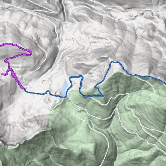
As you can see on the map below, the route between Greenwood Lake and the area south of Griffin Mtn could be improved. My route, in red, falls outside of the watershed (blue area) for much of its length. The historic Cowlitz-Nisqually Trail (purple) also runs outside of the watershed for much of this area, following the western and northern flanks of Griffin Mtn, rather than cutting across it’s NE flank. I’m sure the natives and James Longmire had good reason for skirting so wide around the summit – this is a tall peak, cliffy, and the NE face was likely was difficult to cross.
Altho they don’t line up in the image below, I suspect my route across the northern face followed the historic route up to the point where the abandoned, de-inventoried road split (where my red track splits). Here, I went north and east along the road-grade, but I should have gone west. Indeed, I found the other end of that northwesterly road grade at the top. A better route would connect the two ends of this road-grade, or even follow the historic route, if there were a path or grade there. These old roads are very choked with alder, however. I had a very difficult time doing just what I did. Of the roughly 4 miles I did from the 85 Rd to my turn-about point, it seemed at least 2.5 of those miles were spent crawling thru alder nearly as thick as my wrist. At about the 3800′ level, the road-grade became impossible to discern, the timber between here and the next section of old road-bed was extremely thick noble fir, and quite difficult to pass thru. A different route would be very desirable.
I found evidence of other abandoned, de-inventoried roads on the NE flank of Griffin Mtn. If they could be followed up toward the peak, I could likely cut off some miles to end up on the ridge line sooner, while staying just inside the watershed. The only evidence I can find of these mysterious roads is on my Greentrails maps, tho.
After I worked my way back down from Griffin Mtn, I followed the route up to the trail head near Greenwood Lake. All road, no brush, very easy to travel. I encountered no traffic, but was rather fragged by the time I stopped to eat. At least it was an easy trip down!
No pictures taken on this trip – again, I just wanted to log miles.

Leave a Reply