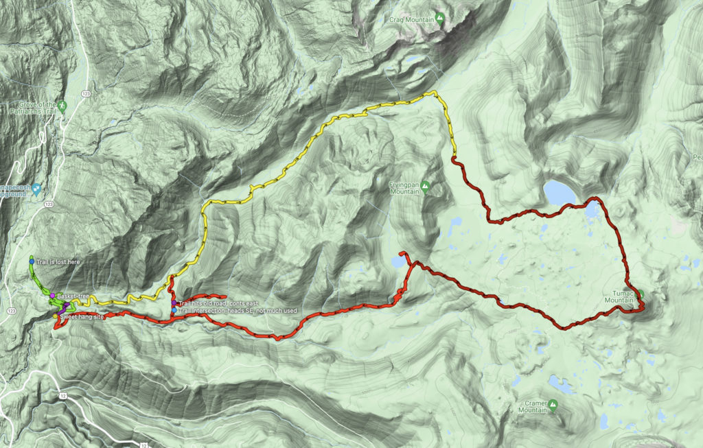
Historical trails have been something of an interest for me for some time now. I’ve been researching and traveling the Cowlitz and Klickitat Trails in the Gifford Pinchot National Forest, among some of the oldest in the region, dating to some thousands of years old. I’ve traced much of the Cowlitz Trail from Randle up to Packwood, and beyond to La Wis Wis and up to the Tumac Plateau. One area I had yet to explore, having only recently located it, is the historical crossing of the Cowlitz Trail at Summit Creek, above Ohanapecosh, between USFS 44 (Carlton Creek) and 45 (Summit Creek) Roads. Last April, I had traced the historical trail, via fisherman’s paths and an old road cut, from the 44 Rd down to Summit Creek in the canyon below, but the stream was too deep and swift to risk a crossing attempt. I also parked at the appropriate location on the 45 Rd, but, after many days of hiking and biking, was not feeling energetic enough to clamber down the steep draw to attempt the crossing.
Today, with the crossing as a destination, I park my truck at the Carlton Creek washout on the USFS 44 Rd, and set off with a backpack loaded for four days, and an intention to take the long way – up Carlton Creek Trail #22, up the PCT along the Bumping River, over Tumac Peak, and back via Cowlitz Pass. I had not quite decided yet what my return trip would look like.
The first many miles of my route is up the USFS 44 Road, washed out at the first crossing of Carlton Creek, just above its confluence with Summit Creek. The morning air is warm and already a bit dusty, and I find a group of horsemen utilizing a large horse camp and blocking the road approaching the trailhead. No matter, I turn around and park on a nearby pullout and get loaded up. Making my way down to the trail head and stream crossing, I am gladdened to see the Inipi (sweat lodge) is still there. I am a little less gladdened to see a small bridge is being built – sturdy enough for bicycles, but also for ATVs. I’m not sure what’s going on there… but at least I don’t have to take off my boots 10 minutes into my hike.
I spend the morning and early afternoon walking up the old road, heading west, then north, then northwest, making my way to Carlton Pass, then Fish Lake. The trail is in good shape all the way, but it doesn’t look like it’s used very often. As I ascend the trail, the forest transitions from Douglas Fir and Hemlock to Silver Fir and Spruce, Vine Maple transition to Douglas Maple on the scree slopes beneath cliffs.
The trail joins the PCT at Fish Lake, where my route turns south. I consider camping at the PCT crossing over the river, but in looking at the time, I decide to push on and take advantage of a few more hours of light. My first goal is Twin Sisters Lakes, but I know I won’t make it that far today. I am simply hoping for a nice camp, with a view of the sky, near water, and far away from other hikers. I find that perfect spot a couple of miles above the crossing. This is an old camp – a recovering horse ford across the stream is filled in with logs in favor of a new (relatively speaking) bridge, but a half-dozen nice campsites are still usable on either side of the river, which is really just a very lovely stream now. I have the whole place to myself.
I select a site alongside the creek, with a perfect hang near the water, a fire ring and sitting logs near the clearing, with a great view of open park and wide skies to the east. The flies and mosquitos are coming out, but they’re not too bad. By 7:00 pm, I have my camp set up, and dinner is cooking in the bag. The sun slowly descends behind me, shadows creeping toward the meadow, birds singing their evening songs. The slight easterly breeze is not enough to worry my cookstove, but it feels nice.
“Hello!”
A fellow hiker shows up, having hiked up from Hwy 12 over the afternoon, decides no other campsite is suitable for his tent, and sets up in the site next to me. Fortunately, the bugs are coming out in strength now, so he retreats to his tent, and I’m left alone for the remainder of the evening. TBH, that’s the way I prefer it. I eat my dinner in contemplative, buggy silence, then spend the rest of the evening reading a book on my phone and sipping my evening tea – and slapping wee flying biters. Eventually, the light drains from the sky – the languid change of light brings a fascinating view to the wilderness – color fades, the sky dims, the stars appear and begin to twinkle one by one, the brightest few showing up long before the rest. Bats take center stage now – shadowy forms flickering at the edge of vision above the meadow and amongst the trees. With no moon tonight, the darkness is somewhat more profound than it would be otherwise, but it certainly isn’t a full dark. I do need a headlight as I gather my phone and put my belongings away, but star shine is enough to find my way to my hammock.
+
The next morning dawns bright, clear, and dewey. The meadow is crusted in diamonds and birdsong fills the air, still as bated breath. I had set up my stove with a pot of water, ready for just a flick of the lighter to get my coffee going. One flick later, I’m perched on the log, looking out over the meadow, and making my morning plan. Hiker-neighbor is still asleep, but last night had told me he and his wife had actually started hiking the PCT at the Columbia River, and were turned back by snow as they approached Pahto. His wife was done hiking, but he wasn’t, so he drove up to White Pass. I had thanked him for the beta, and spent the night wondering if I wanted to stick with my plan to hike to Elk Pass and out via Coyote Trail and Coal Creek Ridge, or simply to Tieton Pass to make my down the Clear Fork Cowlitz.
I pack up my gear as I make breakfast, and hit the trail with my third cuppa dirty chai in hand walking past the other fellow’s tent just as I hear him un-zip the door. The sun is just beginning to peek over Mt. Aix and Bismark Peak, and the sideways warm, golden glow is beginning to infuse the meadows to either side of the PCT as it gradually ascends the headwaters of the Bumping River toward the Tumac Plateau – a broad lava plain dominated by the cinder cone of Tumac Mountain. I take a left to head east at the Twin Sisters Lakes Trail #980 and continue climbing, eventually coming out at the larger of the two lakes, and continuing on to a sandy beach along the smaller of the two, from which a good view of Tumac Peak can be had. I shrug off my gear, and settle in for a break. It’s taken me a couple of hours to get here, and it’s mid-morning now. The air is beginning to thicken a bit with airborne protein, but nobody is biting yet. Fish are jumping in the lake, ripples distort the reflection of Tumac and the cloud-free skies. I perch on a smooth boulder which juts out into the water, and give myself space to simply let the morning slip away.
It was a good try, but my feet get antsy after only about 15 minutes. That peak is beckoning, I can see two potentially problematic snow patches high up on the trail, and I am eager to see just how difficult they will be. The last time I was here on this sandy beach, Tumac looked too snowy to attempt. This time, however, it’s a bit less snowy, and I’m a bit more game. It’s a tough climb along the Sand Ridge Trail #1104 and Tumac Peak Trail #944 up to the summit, and I stop to rest among the thickening bugs a few times. A group of young men, in 501s and tennis shoes, is making a very noisy approach behind me – I step well off the trail and give them a good while to get out of my sight. It takes them a while, as they’ve encountered me just below where the trail disappears under the first large snow field. The map obviously directs one along a switchback east – indeed I can see a cut log up above. I watch as they ignore the switchback, and slowly struggle up the wrong way, shouting and hollering to each other all the way. “Have you found the trail yet?”, “No trail here, try over to the west!”, “Ouch! These bugs are horrid!”, and at one point, “Oh my God!”…
I don’t know what that last was about, but as they’ve now disappeared behind the yellow cedars above me, I step back along the trail, and slowly huff and puff my way up, stopping in the shady spots to cool down and catch my breath. My pack feels heavier today than yesterday. Much heavier, more-so the further I go. I follow short sections of trail, cross over increasingly larger snow patches, switchback a few times, always going up, up, up… After a while, I’ve caught up with the four mis-directed boys, who have finally come back out to the trail. They’re taking a sweaty, panty break, and looking up at the last section of trail above. One by one, they talk each other out of the attempt. I wait down the way for a bit for them to gather and get on their way, but finally have to announce myself and push thru. They’re all pretty polite, but none are masked. I’m thankful for my bandana. By the time I reach the first and larger of the two snow patches, they’ve departed – perhaps they had an easier time following my tracks down. Yellow cedar is no fun to bushwhack thru.
It’s really quite exhausting kick-stepping my way across the larger snow patch, and the second makes me a tiny bit nervous, but I am across both and ascending the last switchback after only about 15 minutes. Legs exhausted, I am very much in need of shade and a sit-down, but there is neither to be had. I bat my way thru clouds of bugs to the summit, then shrug off my gear again for a well-deserved break. Mt. Rainier looms behind me, Mt. Adams and the Goat Rocks are visible in front of me, above the ski trails of White Pass – I’m at the easternmost point of the Upper Cowlitz watershed. I sign the trail register, and dig into my trail mix. The high county above White Pass is obviously going to be a problem – I doubt I can even reach Tieton Pass. Given the Mt. Adams beta and what I had seen see of Hogback Mtn on the webcams at home, I think it foolish to attempt either, so settle for a trip out via Cowlitz Pass and Summit Creek. I spend a while longer sweating on the sunny peak swatting bugs.
The trail down the peak only takes a few minutes, and before long, I am back in the forest, flies and mosquitoes getting worse by the minute. The trail worsens as I descend, becoming muddier and muddier. I begin to have problems keeping my footing on the trenched, slick path, and I fall a couple of times. The trails here are in terrible condition, and do not receive maintenance. The plateau is not fully melted out yet, the trail often covered in large snow patches. It makes for difficult travel, and I did not enjoy this section. By the time I get to Penoyer Lake, I am exhausted, muddy, and hot. I find a shady spot alongside the grassy shore, and flop down for a break. I can see I will be at the Soda Springs Campground by dinner time, and I’m not really keen on that. Jug Lake makes a nice detour, and will likely offer a campsite. I dig back into the trail mix. Once I feel a bit fresher, I set off, leaving the Cowlitz Trail #44 for the Jug Lake Trail #43
I arrive at Jug Lake in the late afternoon, following the trail to the western shore of the lake – there aren’t any nice campsites along the shore, but there is an area that is obviously used a lot, with bits of trash here and there, and rope remnants hanging from the trees, many of which have been hacked at and scarred by campers. I find a place to string my hammock up, and set up my small campsite such that I can turn my back on the worst of the ugly. I’ve a short walk down to the grass-bounded lake shore, and the inlet stream is about 3 minutes up the trail. It’s a quiet night, and I’ve the lake to my self. The bugs are a problem all night. My mosquito headset is a permanent fashion fixture at this camp.
+
I’m up at first light and on the trail by 6:00 am, mug of dirty chai in hand. The bugs are practically chasing me out of camp. Bug spray is ineffective, and I’m grateful for the bug net. I plan to eat breakfast once I hit the campground, but stop once at Summit Creek to make another cuppa. It’s a quick trip down to the nearly full campground. I am able to find a campsite, and set to getting breakfast going. Down here, the bugs are not a problem, and I enjoy a leisurely morning, the sounds of the campground providing a refreshingly different soundtrack for my morning. Eventually, however, it’s time to go – I swing by the Soda Spring for a swig, then make tracks down the USFS 4510 to the USFS 45 roads – these following the original route of the historical Cowlitz Trail. There his almost no traffic, and I enjoy my stroll down the road. A couple of miles below the campground, I spy a foot path leading up into the forest.
Aha! I have been traveling with the historical maps loaded onto my phone, and upon checking, I confirm this is the location of a branch of the historic trail which connected to the Carlton Creek Trail. It crosses a short distance to an old road, which itself follows the route of that historical trail. I do not hesitate, and make my way up the footpath. The trail is in great shape, easy to follow, with recent, tho infrequent use, crossing over fairly level terrain then over a creek before following the road out to the 44 Rd. I decide to follow this out to the Carlton Trail, to close the loop, noting the fact that an obvious path also went up the road. Earlier, when studying these maps, I had noted this road approached the Carlton Ridge Trail very closely, but no map showed a connection. I resolved to follow this upon my return, and doing so, found it actually does connect with the Carlton Ridge Trail. Having explored this network of trails between Carlton Creek and Summit Creek, I was satisfied. I love exploring these sekrit trails. The more of the area I explore, the more I find there are countless, unmapped routes to explore. It’s all very fun. I did find another, faint trail taking off to the east, but didn’t explore it. Another time.
Back to the Summit Creek Rd, I continued down to the bridge and now-closed Summit Creek campground. It’s a day use area now, and the entries are blocked and dug up. Being on foot, it was no matter to me. I found a nice shady spot on the edge of the canyon, and set into lunch. I did note a trail taking off from the end of the bridge – it may also go back to the Carlton Creek Rd, but I didn’t follow it. My destination is actually further down this road. A couple of vehicles go by while I am taking a break, but in general, the area is quiet. I contemplate a nap in the sun and breeze, but decide I’m not really tired. I shrug my pack back on, and continue another two miles down the road.
Finding myself at the small spur road where the historical trail is shown to drop down into the canyon, I turn off the road and into the forest. The trees here are small, the soils thin, the forest floor covered in emerald moss. It’s easy to navigate and I follow the terrain down the draw. I have to step over or around fallen trees here and there, but I am able to discern, and keep to, a sometimes visible tread thru the moss. As I descend deeper into the draw, the tread disappears entirely, and the trees get a bit larger, but there are more fallen trees which I must clamber over/under/around. I step carefully down one final steep drop and find myself on the south bank of Summit Creek, exactly where I expected to be. I’m standing on an ancient road cut, and looking across the stream to where I have stood months previously. I step down a few more feet, onto the smooth, emarald- and black-moss-covered rocks, and carefully make my way to the water’s edge, at a narrow chute. I take a short break here to change into my creek shoes, then carefully step into the stream. It’s only mid-thigh deep here, and easy to cross. I can see from the banks, however, that the stream can be much deeper here during times of higher flow. I am immediately across, and find myself at a perfect campsite.
After enjoying a sublime evening with a campfire and having a sound sleep alongside the stream, morning starts with ouzel-song. I have a lazy morning, enjoying the relatively bug-free environment, soaking in the river-song, even taking a bath in the stream. After much relaxation, and much dirty chai, I set out on my exploration for the day. I intend to explore the historical trail from here to Ohanapecosh. I expect to find some of it, but rather doubt I’ll make it all the way. Setting out with a day pack, I follow the trail, as best I can, out to the road. The old maps are inaccurate here, the contours way off, and the trail is shown traveling along the base of a talus slope, over a minor saddle, and down to what is now the road. I am actually able to find excellent indication of the trail in a line of stacked stones, covered in eons of moss, in exactly the correct position at the base of the talus. Continuing, I find vague remains of tread following the terrain as one would expect. Following the route on the map beyond that, however, leads me to sidehill up the ridge to a saddle. It is a steep climb, and while I find some vague hints of old tread here and there, they don’t necessarily line up, so I don’t know if it switchbacked here, or if I am on game trails. I stick to the mapped route, however, and soon reach a minor saddle. I now am starting to doubt I am at the correct location, however, as I can now see that the contemporary road is well below me. If this is the actual historic route, it wasted a lot of elevation in light of the fact that there is an almost zero-gain route to be had by simply walking up the canyon… Additionally, that old road cut down in the canyon at the crossing continues out of the canyon, passing very near where I lost the trail, and it obviously dates from the 1930s to 1950s. I begin to develop a hunch that the old road-cut is actually the old trail, and that the maps are (understandably) inaccurate.
I’m on something of a trail here at this minor saddle, however, so I decide to go ahead and explore. The vague trail continues westward, but is hard to find in places, and I’m not convinced it isn’t just a game/hunter trail. I turn downhill, and make my way down to the road, then dive back into the woods where the map shows the historical trail – no good, I can’t find any trail sign here, so I work my way up to that minor saddle, then follow the ridge line down into the clearcut to the old road cut. I quickly pop out to the road and stop by my truck (I need to grab more food and whiskey!), before I set off on my second goal for today. I walk down the 44 Rd and make way for a pullout camp not too far down the way. The old trail takes off from the back of this camp.
The trail is easy to follow, but I follow the wrong one, and it simply disappears some way up the hill. Looking at my map, I see I need to be some way west of where I am, so I simply cut thru the open forest, crunching thru knee-deep salal. It’s pretty obvious when I get to the trail, I easily follow it into the National Park. The trail is shown to pass up a draw from here to a broad level area, then down another draw to the Ohanapecosh Sewage Plant and on to the Highway. I am able to follow the increasingly vague trail up the one draw, but lose it in the rotten logs approaching the other draw. I scout around, but am not able to find anything visible. Roughly 2/3 of the way to Ohanpecosh, I turn back.
Back at camp, I enjoy a long nap and another relaxing evening, this time with no fire, but lots of bats. The next morning, I’m up and packed pretty early, and am to my truck by 7:00 AM for Stage II of my vacation… which is it’s own trip report.
Leave a Reply