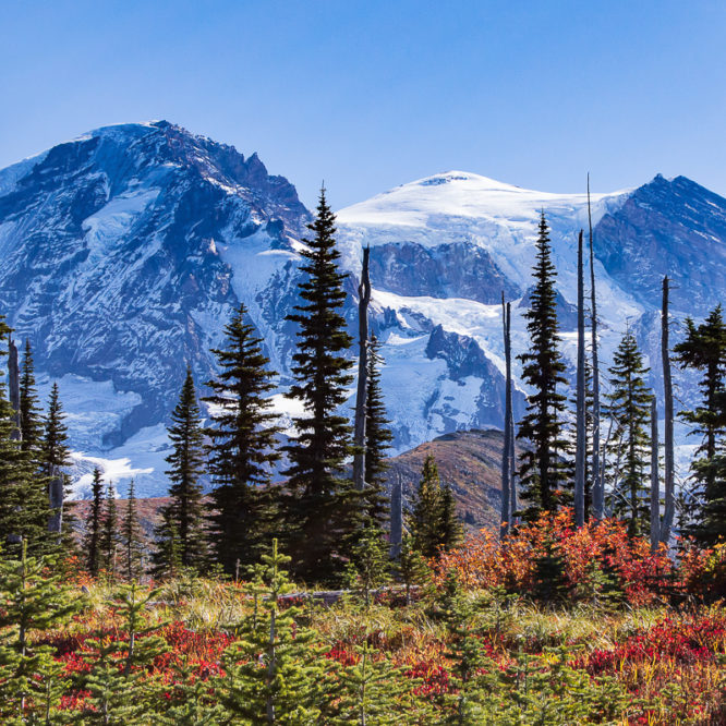
And on your left, Mt. Rainier.
It seemed a continual refrain as my brother Barry and I circuited, counter-clockwise, the imposing presence of Mt. Rainier along the famed Wonderland Trail. A celebration of cancer survival, it seemed the only thing big enough.
I had applied for a permit the minute the website opened on March 15, and received our reservation confirmation for Permit #106821 April 22. I booked my annual leave at work. I took practice hikes and made sure my gear would work. I patiently waited through the summer for September, when it would be time to start following the weather forecast. Finally, everything came together and we were off with the promise of a great time and excellent weather.
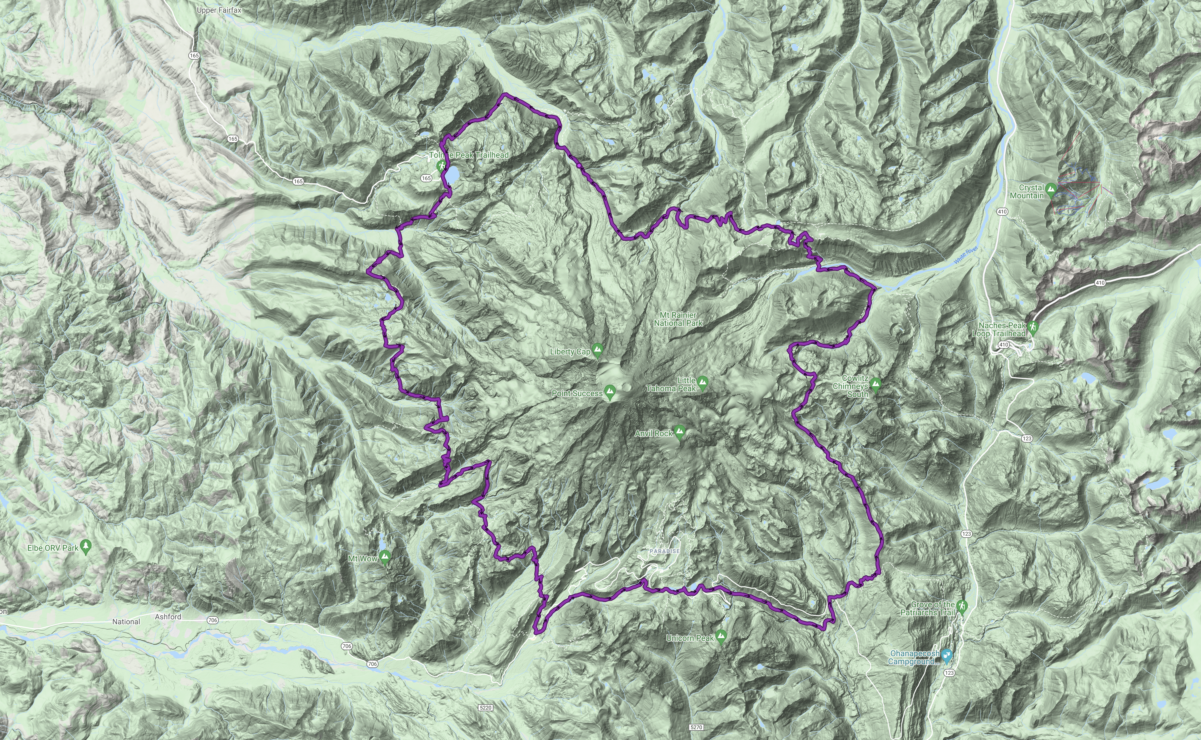
We parked at the Sunrise parking lot, MRNP, setting off down the service road to the Wonderland Trail at 5:00 PM Sunday, September 23, 2018, returning October 2, at around 3:00 PM. We hiked a total of roughly 105 miles, with nearly 3,000′ of gain most every day, for a total approximate gain of 23,717′ and loss of 22,702′! The weather was fantastic for most of the trip, there were no bugs due to the late season, and we had no real problems with either our gear, our selves, or with each other. We hadn’t spent this much time together since the 1980s. We managed to successfully solve the huge problems of religion and politics. The dirty chai was the bomb!
Day 0: Our first night was at Sunrise Camp, along the shore of Shadow Lake, 1.2 miles from the parking lot. Not a big day, but we didn’t want the hassle of trying to cram a day of travel and a day of hiking to Mystic Camp all in one day. A good call, if I say so myself. We had a nice, if cold, camp site. In getting water at the lake, we saw a Cascade Red Fox – a rarity, and found largely only at MRNP, and at Mt. Adams and the Goat Rocks. I didn’t have my camera on me, sadly enough. She was in transition from summer to winter coloration. I found out my Petzl Tikka headlamp won’t work. We gained no elevation today, dropping 155′ down to camp from the parking lot. We hiked a whopping 2.7 miles today.
Day 1: Froze our tushies off overnight, but had a great hike up into Berkeley Park, where we encountered a marmot, to the Skyscraper Peak trail. We ditched our packs here for a quick ascent and gorgeous views. We encountered Germans (carrying a full circuit’s worth of food, and grumbling about it), a gaggle of older ladies, and a trio of Northern Loop-bound women. The drop down to Winthrop Creek was uneventful, and the trudge up to Mystic Camp seemed long, but only because it was the first full day of hiking. Mystic was cold, and not a pretty camp, but the lake was sublime. We followed the shore a bit, went up to the patrol cabin, and gathered water at the outflow. I rescued a forlorn, heart-shaped, pink Mylar balloon to send home at Mowich. Our elevation today ranged from 6,245′ to 7,078′, then down to 4,600′ and back up to 5,570′ (+1,763′, -2,478′). We hiked roughly 10 miles.
Day 2: Climbed up the last bit past the lake to the 6000′ shoulder of Old Desolate, a mountain that had been dominating our views since the Winthrop Glacier, to begin our long drop down to the Carbon Glacier and the suspension bridge. And then up, Up, UP! to the Summit of Spray Park. We rolled, exhausted, into Eagle’s Roost Camp just as the fiery orange sun sunk below the horizon. Our elevation today ranged from 5,570′ to 6,000′, dropping down to 3,200′, then climbing up to 6,400′, before dropping back down to 4,900′ (+3,630′, -4,300′). We hiked roughly 12 miles today.
Day 3: We left camp and headed for Lake Mowich Patrol Cabin (4,929′) to pick up our cache – this one is self-serve. My phone died today, and I cannot get enough sun to charge it. Encountered a couple from North Carolina. Nice hike down to the Mowich Rivers, but wasted a bit of time filtering water at Crater Creek, as I failed to comprehend the utility of releasing the vapor lock with a quick bag inversion. D’oh! Quick lunch on the south bank of the S. Mowich, then up that long grind to Golden Lakes. We moved on. Golden Lakes Camp was nice, complete with a pop-up Ranger Rick at the patrol cabin, and a group of laughing ladies nearer the lake. Our site was small, and the camp was full. An easier day today, our elevation today ranged from 4,900′ down to 2,605′, then right back up to 5,130′ (+2,554′, -2,324′). We hiked roughly 14 miles today.
Day 4: Today, we dropped down into and across the North Puyallup and up to Klapatche Park Camp at Aurora Lake. Encountered a bear in a small trail-side meadow not long after leaving camp, and then immediately afterward, North Carolina. They had had a more intimate encounter with the bear, and I think they were a bit shaken. They were also wearing cotton. I assured them the bear was harmless, and then had a bit of harmless fun sharing my “You know what’s not harmless? A lahar!” spiel. When their eyes had glassed over, I felt my job of helping them get over their bear trauma was done. We had Klapatche Park Camp and it’s view of the urban corridor below all to ourselves, as well as the stunning alpenglow on Mt. Rainier’s Puyallup and Tahoma Glaciers. Sublime. Water was not to be had here, however, and we had to hike a round trip total of 1.6 miles to St. Andrews Lake to get our water. Our elevation today ranged from 5,130′ up just a bit to 5,200′ and gently down to 3,700′, then up to 5,920′ before arriving at 5,500′ (+2,290′, -1,920′). Today came in at roughly 9.8 miles.
Day 5: Today, we crested three different ridges – St. Andrews, Emerald, and Indian Henry’s Hunting Ground. Another gorgeous day, but some clouds are gathering. Arrived at Devil’s Dream Camp to find we had it all to ourselves. Nice! Our elevation today ranged from 5,500′ up to 5,600′, down to 4,200′, then back up to 5,600′, down to 4,300′, and back up to 5,300′, finally dropping back down to 5,060′ (+3,400′, -2,940′). We hiked roughly 10.9 miles today.
Day 6: Cache day at Longmire! The sky is grey today. It is weird to arrive at that first contact with the highway to hear and smell cars and trucks, motor-homes and motorcycles. I do not care for this development. Lots of people at Longmire, although nothing to what it would be were this the tourist season. And again, the pack is heavy – another unwelcome development. The camp I wanted – Paradise River Camp – is closed for hazard trees, and we are routed to the Cougar Rock Walk-in Camp. This is a car camp, the small group site reserved for all Wonderlanders is over-run with a mob of off-road enthusiast car-campers. They are noisy and smelly, and I am pissed! I finally settle down, and we decide to simply take one of the numerous unreserved car sites in the otherwise closed section. We could still hear the off-roaders, but it wasn’t too bad for the distance. A ranger drove by once in the late afternoon, and again in the morning, but made no contact with us. Damn good thing, as I had an opinion. It rained shortly before dark, with brief showers sporadically throughout the night. Our elevation today ranged from 5,060′ down to 3,600′, and then up to 3,900′ before dropping down to 2,700′ (+300′, -2,660′). This was our short day with only about 7.7 miles hiked.
Day 7: Glad to leave Cougar Rock, we marched up to Inspiration Point and Refection Lakes, to enter Cowlitz Country – a kind of coming home, the headwaters of our childhood, so to speak. The whole trip down Stevens Canyon was nice – blazing canyon walls, maple groves, a wild stream, Box Canyon… The whole day was damp and misty, and the rain finally caught up with us at the Box Canyon. Fortunately, Nickel Creek Camp was not far off. We were assigned the group camp site here, and I’m glad for it – the sites here are few and small. Nickel Creek is delicious. It rained throughout the night. Our elevation profile today was simple – from 2,700′ to 4,850′, then down to 2,600′, and back up to 3,400′ (+2950, -2,250′). We hiked 11.5 miles today.
Day 8: Today I had hoped might be our most scenic day, as we climb the Cowlitz Divide, cross Indian Bar, ascend Panhandle Gap, and drop into Summerland. It was not to be. Instead, it was windy, wet, and cloudy, with visibility reduced to mere dozens of feet at times. I loved it! Encountered Dave&Bridgette, whom the mountain had broken with cold, damp weather. They were headed down to Box Canyon for a hitch-hike back to Longmire. Soon after, we lunched at the Indian Bar shelter, but pressed quickly on. I wish Barry could have seen Ohanapecosh Park, but perhaps another trip. There were lots and lots of interesting purple rocks once we crossed Panhandle Gap – I need to look up why that is. Arriving at Summerland, we were pleasantly surprised to find that being assigned to the group site meant camping in the stone and timber shelter. Not as cute and iconic as the Indian Bar shelter, we were very pleased all the same, and quite drier for it. Again, it rained much of the night. My shoulders informed me that weather was shifting quickly, though. I told Barry to expect good weather for our exit tomorrow. Today, our elevation ranged from 3,400′ to up to 5,930′, down to 5,000′, then up to 6,800′ before dropping back down to 5,900′ (+4,330′, -1,830′). We hiked 11.1 miles today.
Day 9: Summerland has perhaps the most unique toilet in all the park – perhaps in any wilderness area. It looks rustic from the outside, but appears like a jet-liner loo from inside. Because the composting toilet that used to be there failed to compost, a new, urine-diverting toilet has been installed. This has a unique construction rather akin to a grocery checker’s conveyor belt. Urine goes one way, poo is sent the other – the NPS is testing claims of better waste management via urine-diversion. There is a solar panel atop the loo that runs fans and an electric light for nocturnal users. All this at 5,900′ elevation! There is even a can of Glade – can you guess which scent? It turned out to be a gorgeous day, and we encountered two aspiring young models – fat, preening ground squirrels – alongside the trail. We had lunch at the White River Boy Scout cabin, then made that last, most difficult climb up to Sunrise. Today’s elevation ranged from 5,900′ down to 3,900′, then finally back up to 6’400 and our exit. We hiked 10 miles today (+2,500′, -2,000′).
It was very exciting to walk that final short distance across the sandy trail to the parking lot. It’s amazing how energized one feels when the end of the is actually upon one. We may have laughed and whooped and hollered. There were hugs and back-slaps. We had done it – two brothers, cancer survivors, one trail, one Mountain.
We celebrated our great hike with burgers at the Naches Tavern, Greenwater. I had a double everything with grilled onions. God, did that taste good.

Leave a Reply