My homeland – the High Cowlitz. This page is dedicated to the exploration of a route that traces the watershed divide, wherein are collected all the waters that flow thru Cowlitz Falls Dam, previously a sacred site to the original Taytnapam people, indeed their very center of creation.
Even though this sacred site has been blasted out of existence, buried beneath a dam and flooded beneath a lake, despite the destruction of the lowland and montane forests thru which the river and all its tributaries course, and the loss of species and habitat throughout the watershed, you can’t help but notice this entire area possesses, or perhaps creates, a spiritual power.
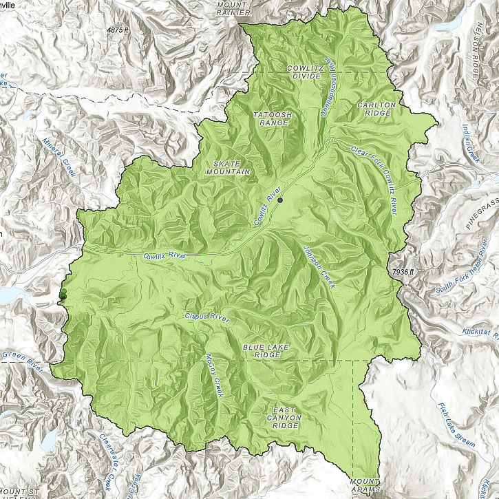
Looking at the map, you place your finger on the location of the dam, elevation roughly 800′. From there you trace a line widdershins along a high point – and imagine yourself standing there, atop a ridge, to the left, the watershed of the Upper Cowlitz, to the right, the whole rest of the world. How can you not go on? You climb higher.
You always keep to highest point, always keep the sweet, melodious, strange waters of the Cispus and Cowlitz to your left. Keep one foot stepping in front of the other, regardless of grade or exposure or risk of certain death. You’ll rise from the lush, exuberant lowlands, into the majestically overwhelming montane forest, and higher to exquisitely delicate and ridiculously tough sub-alpine and even bare exposed rock. You skirt the devastation of Mt St. Helens. Bare exposed rock, jagged and impossible. Ridges sharp as a knife, the ground plunging down beneath you on either side.
You stroll across wide mountain tops, spotted with meadows, along lakes large and small. You climb up, you climb down, and you do so much more climbing, thru down timber, burned and not, windblown, thown and tossed. You come to cliff faces with no possible way up, but that does not deter you. Up you go, and up some more, and down. Eventually, you come to a great white expanse before you – Mt Adams, Pahto, clad in snow and ice. Without a pause, up you go.
You stand on The Pinnacle, the very summit of Pahto at 12,276′ elevation, and then start right back down again, but pointed north. Your feet carry you effortlessly along this high line of distinction and definition and danger, for now you are heading down the rotten crumbling flanks of a stratovolcano, across a broad flat volcanic plain, and then up along the Cascade Crest, all with the forbidden Yakama Nation on your right. into the Goat Rocks full of sheer, fragile rock, and sure footed billies and nannies and kids, taunting you with their complete disregard for gravity. You laugh, for gravity is not your foe, and you have a bit higher yet to go. Up and over countless rocky peaks distinguished only by their individual elevations, they read like a cipher. 6289, 5935, 5823, 6070, 6257, 6401, 6201, 6184, 6503. Up the Black Thumb and Big Horn. Over Ives and up Old Stormy, to where the headwaters of the Tieton and Cowlitz kiss, ever so tenderly in the alpine grasses, the sharp glassy stone shift beneath your feet musically.
You continue to follow the ridge line, always with the Cowlitz to your left. Miles and lakes, ridges and peaks, forest and meadow all pass beneath you, roadways, a ski area, then a wide plateau. You summit the cinder cone near the center of the volcanic plain, dotted with literally hundreds of lakes. You work your way down again and up again, past more lakes, and more roads – Hyas Pishpish, Naches, Tipsoo. Soon you notice you’re now traveling west, The Barrier, Governor’s Needle, Cowlitz Chimneys. A great white expanse even larger and more intimidating than the last is now looming before you, Tahoma’s mighty glaciers blind you in the mid-day sun, Banshee Peak, Whitman Crest and Little Tahoma. Now you crest over bare rock, steam is rising from fumaroles beneath your feet at 14,410 feet above the Salish Sea so very, very far below you.
You might pause here to soak up the vast views in absolutely every direction, there’s nothing above you but deep, dark indigo sky. Perhaps you would seek shelter in the steam caves, were a storm to come up. I’ve never been to the top of mighty Tahoma, so I couldn’t tell you exactly what you’d see and do. Seems to me pretty much the whole world would be laid at your feet. What couldn’t you do?
Turn your sights south when you’re ready, the Beehive, Anvil Rock, Muir Peak. The Sugarloaf and McClure Rock. Paradise. The Tatoosh Range, up and over Wahpenhayo and down to historic Longmire 3500 feet below you. You enter a lower and rougher country now, the forest here used hard. Historic trails used to traverse this rough and tumble land, tho, and between the shape of the land, and the shape of the roadways, you can nearly discern this ancient trail beneath you. It could simply be your imagination, but you follow this to a small valley, dotted with homes along a hi-way, up and over a small mountain, and suddenly, you are back down at the dam, staring across the river where you started, not so long ago.
Of course, that’s a lot of work, and likely not possible. Not by me at least. So I found a route that approximates all of that above, but one that is actually do-able. I’ve been piecing it together, section by section, over the past few years.
I call it the High Cowlitz Super Loop.