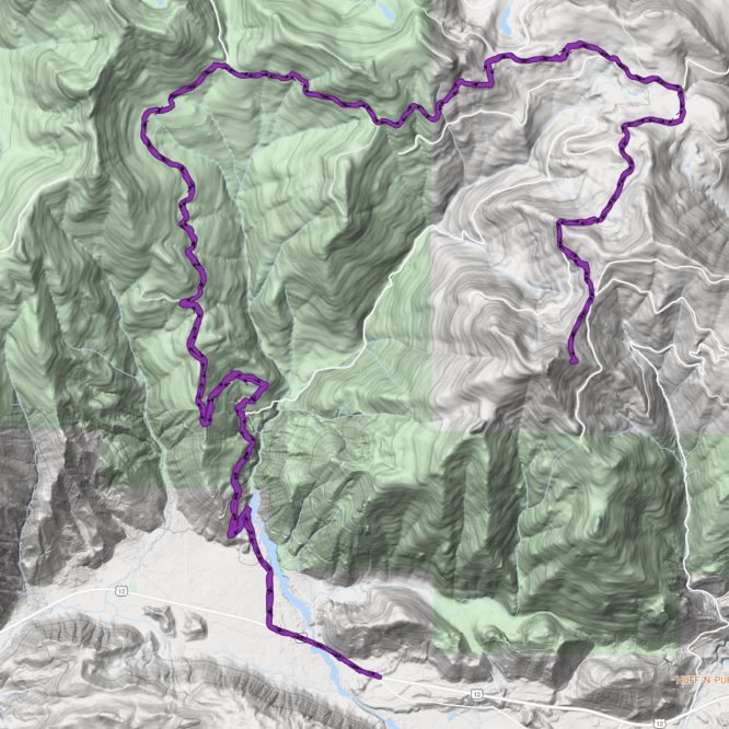
How is it July already? Summer is getting on, and I’m eager to be getting up into the high county. My recent trip up to the PCT at Divide Camp leads me to think July 1 is still too early to be getting up into the Goat Rocks or high Tatoosh, but I’ve still some low-lying areas to cover. Here, I’ve completed the ‘Kiona Trail’ section of the route. I started on Pepper Ridge Rd off Hwy 12 and worked my way almost to the top of Kiona Peak.
I’ve been excited to complete this section because of a discovery I made while surfing online mapping services. I found that Caltopo (caltopo.com, I love this site so much!) offers a variety of map layers, including two historical layers – one is labelled ‘Historic 1895-1915″, the other “Historic 1915-1945”. The earlier layer is blank – I suspect there are no gps-enabled scans of maps of this area from this “homesteading” era. However, the pre-WWII version is available, and very interesting!
One of the most fascinating things to notice is the relative lack of development. The Big Bottom valley was only sparsely populated prior to WWII. Homesteads dotted the valley, and clear-cuts scarred the valley walls, but beyond that much was yet unchanged. Many of the original trails are still extant on this version of the map, and many of those would have been the Native American trails that had existed for centuries, if not millennia.
The Cowlitz Trail is a familiar historic trail I’ve been getting to know better these past few years – it took travelers up into the high country, and over to Yakama territory. Some of it is even discussed on other posts in this blog. A different trail, however, is new to me – the Cowlitz-Nisqually Trail. This trail began on the valley floor alongside Stiltner Creek, very near where today one finds Scott Rd and a couple of small, but be-loved, cemeteries. The trail is only a historical footnote, but logging roads approximate the route. It wound it’s way along the watershed divide, cutting generally north and east to the Nisqually watershed and Bear Prairie along what is now Skate Creek Road. (And yes, Skate Creek road used to be a trail, too!) From Bear Prairie, the trail continued to Longmire.
Th earliest mention I can find of this trail online is a passage from from a scanned article in the Atlantic, volume 38, from July 1876, https://books.google.com/books?id=FWAwAQAAMAAJ&printsec=frontcover&source=gbs_ge_summary_r&cad=0#v=onepage&q&f=false. It describes a trail having been blazed up the Nisqually, down to the Cowlitz, and up to Mt. Rainier, about 10 years before the historic ascent of Mt. Rainier by Hazzard Stevens and Philemon Beecher Van Trump in 1870 – meaning this trail likely dated from at least ~1860. In the article, I gleaned that James Longmire is credited with having ‘marked out’ the trail. Given that the trail travels ridge lines and provides a relatively direct route between resource-rich areas of the Nisqually and Cowlitz rivers, I am assuming the trail likely existed prior to Longmire’s Civil-war era explorations, altho I cannot determine if it was as developed and heavily traveled as, say, the Cowlitz Trail going up the Cowlitz River.
If one looks at the historical maps for this area, it quickly becomes evident that the logging roads were often laid down right on top of these historic trails. There are variances, of course, to provide easier grades for the trucks, but for the most part, today’s route follows the civil war-era (or older) route. In the picture below, my route is indicated in red, the historic trail is traced in blue. The map also shows that during the pre-WWII period, a trail extended south to Kiona Peak, where a fire lookout had been built.
I would assume that historically, the Cowlitz-Nisqually route traveled thru some heavy old-growth timber. Today, it travels thru private timber-lands choked with dense 3rd-growth timber. It’s not pretty, but one can see some interesting geology at road cuts, and some great views are provided along the way.
I parked at the gate, and rode my bike a short way up the road, to the first switchback. There is a good access to the creek to filter some water here, which I did. I then slogged up the logging road, thankful for shade in the gathering heat. At around 3500′, the grade levels out, and the route turns east to parallel a ridge-top before crossing over. Soon after, the road joins another road. I turned right here, to head south toward Kiona Peak, but the original route travels north, joining with the 1 Rd in a little over a mile. I’ve previously covered that area up to and alongside Griffin Mtn.
Kiona Peak was something of a bust – great views, but I did not find a route to the top. I followed the road to its end, had lunch, then turned around. I suspect I needed to stay to the ridge line where the road dipped off it. Another time, perhaps. No pictures – I seemed more interested in keeping moving than taking pictures, and truthfully, besides the rocky face of Kiona Peak, there wasn’t a lot to take pictures of.
My next adventure will focus on a more northerly section of this trail, the area north and east of Osborne Mtn.

Leave a Reply