I’m really getting into “Hammondland” as Nick Zentner @ CWU refers to it… that area north of Hwy 12 and south of Hwy 410. Old and new(-ish) volcanics dominate the landscape. Extreme erosion has revealed ancient North Cascades-related rock. The area is extremely rugged and isolated, and wildfires in the previous decade have all but eliminated access to this particular drainage. What’s not to love?
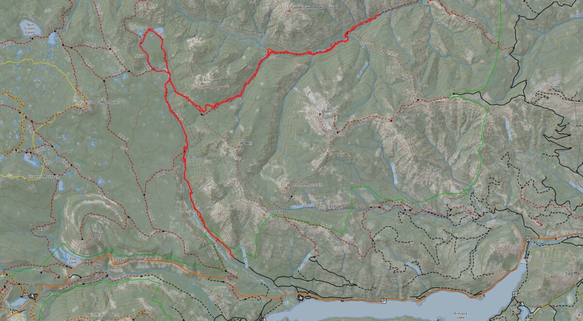
I drove as far up the Indian Creek rd as I dared push my sad old Tacoma. The road proved a simple walk to the trail head, and by first break, I’d made it to the canyon with the white rocks. From there, I pushed on into the highland meadows and hung a hard right at the Rattlesnake Trail #1114.
This portion of the trail seems to get some use, and while I got turned off the trail somehow up near the top of the ridge, I had no real problem finding my way to the first junction, at the Ironstone Mountain way trail. From here the trail descends down to McNeil Creek. While the trail was not hard to follow, it was somewhat choked with downed trees, nothing too difficult, but obviously not used or maintained.
After completing some switchbacks, I could see what appeared to be an old portion of the trail on the valley floor, down a steep slope near the stream. A campsite? Old route? As I continued, I found no connection.
Approaching the flats around Rattlesnake Creek, the trail began to diverge from the mapped route, then simply vanished approaching a stand of timber at the forest’s edge. It seemed obvious I should continue straight on to the stream channel, but I never was able to find an obvious exit for the trail, nor was I able to discern where it would have continued once across the stream bed. The stream bed was dry, and the channel was very rocky, leading me to suspect the stream had gone underground along this stretch. Also, being the edge of the burned area, the forest was much disturbed with downed trees and overgrown thistles.
I was able to pick up a faint tread here and there, much overgrown with weeds, but really I was just picking my way down the valley trying to hew close to the track as shown on my phone but also simply following the landscape. It didn’t take too long before my route took me up to far edge of the valley, and I could hear the stream running again as the channel evolved into a canyon.
From here I picked my way thru the burn, the trail obvious in some places, game trail in others, and completely erased at times. Passing through occasional intact forest, interpersed with open meadows, I contemplated camping in one of these meadows, but recognizing that I’d lost a lot of time navigating the burned over trail earlier in the day, I pressed on, hoping to make as much distance as possible.
As the day came to an end, I realized I was still 3-4 miles from my destination, with no hope of making the mileage up tomorrow, meaning my loop trip up Hindoo and over Mt. Aix, was not going to happen. I decided to bed down near the stream on a sandy gravel bar. The night was beautiful, and the bats were out in force over the stream.
In the morning, I decided I would hike as far downstream as the next trail junction, if that were possible, then turn back and make for Pear and Apple Lakes, which would have been my camp if I had been able to complete the loop. I was only able to make it a mile or so down the stream before I completely lost the trail, so I turned back and traced my steps back out of the drainage.
The slog up the canyon back to the ridgeline kicked my butt, mostly because of the heat. But also, I don’t think I realized how hard I was working to navigate the burned forest. By the time I was back to the Indian Creek trail, I was fragged and it was getting late. It sure was gorgeous walking the easy Pear Loop trail from Indian Creek meadows to Pear Lake in the gathering dusk.
I camped at a gorgeous site right alonside Pear Lake. It was a lovely night. In the morning, many fish were jumping in the lake. The hike out was a pretty simple affair.


Images taken July 26-28 along the Indian Creek, Pear Loop, and Rattlesnake Trails, WOD, OWNF
37.1 miles hiked w/ 5,841′ elev. gain
Leave a Reply